Tag: flooding

  • Ponts de Cé to Champtoceaux

    Ponts de Cé to Champtoceaux

    A day for integrated travel! 70km from Ponts de Cé to Ancenis, and then 10km by kayak, our bikes carried to the downstream dock in a van, then cycling up the final 2km out of the valley and into our warm-showers accommodation in Champtoceaux.

    I remember a forward to a Department for Transport report in which John Prescott set out his vision for ‘integrated transport’, journeys made possible by joining together different modes of travel. I’ve always liked this idea, but I try to mix it with a bit of the spirit of adventure of Jules Vernes and Around the World in 80 Days. Mixing cycling and kayaking definitely fits into this category.

    We ate breakfast at a riverside market at Bouchedemaine, where the Maine river joins the Loire. We’ve skirted Angers, but all the surrounding places we’ve visited have been so friendly that I imagine I’d like the city too.

    We really had to get the kilometres in early today to get to the kayak in time. This is the first time we’ve really had to cycle in tight convoy to keep the pace up and stay motivated that we are covering the ground.

    At Saint Florient, I saw this plaque showing distances measured from the bridge. It was created at the start of a period of measuring and controlling the Loire after devastating floods. Measure it, control it, exert power over it. Except compared to other big rivers I’ve seen in France, the Loire still feels quite wild. Not the freight transport artery I was expecting.

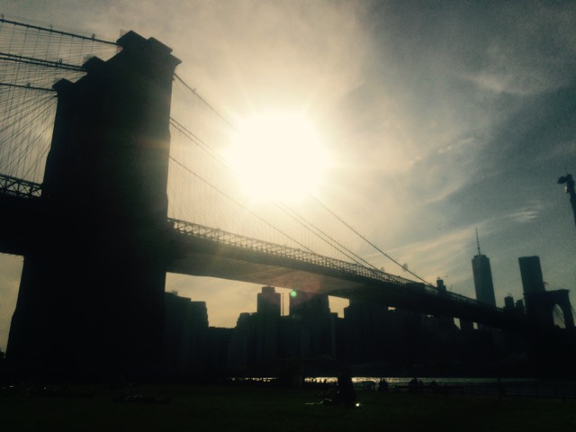
    At Ancenis we see our first major suspension bridge across the river. This is where M & I crossed the Loire on our first cycle trip in France from Saint Malo to Agen in 2008.

    We rendezvous with the kayaks and head downstream. Wonderful to be in and on the water, travelling with the flow. The current is strong but it is safe to moor up behind the groynes that reach out into the river and create little beaches behind. We climb out on a beach and swim for the first time in the warm river water.

    A stop at a guinguette, recover our bikes, then do the final climb to our hosts for the evening, a lovely couple who welcomed us to their self-built home, where we camped next to their guinea pigs. We stayed up talking about their travels with a trailer and a tandem through Sardinia, Scilly, Greece and the Adriatic, and then about how they built their house.

  • Changing the key system to generate new ideas

    Changing the key system is a technique I teach to help people develop new ideas when their thinking has become stuck. It’s one of my techniques for ‘turning the Kalideascope’. In other words, it’s a way to find new creative connections between all the inputs we have gathered.

    What is the key system?

    Design is creating something new. If it already exists, it isn’t design: it’s shopping (for more on this see my post on the Designer’s Paradox). I usually find that the overall shape of that new thing is defined by the answer to a few key questions.

    For example, the overall shape of a city master plan might be defined by the answer to the question: how do we manage surface water. In a tall building, the key question is how do we manage lateral loads. For a song, it might be the rhyming structure or the chord progression.

    In each of these situations, the key system, then, is the flood water system, the lateral stability system, the rhyming structure or the chord sequence.

    The answer to these big questions has such a dominant effect on the solution space that, once they are set, the rest of the ideas develop within these parameters.

    (more…)
  • Parenting x inspecting hydraulic structures in the Frome Valley

    [Written in May, posted today] Saturday was the chance for my one of my favourite kinds of parenting: the kind where I can go on a journey with my daughter at her pace, stop and look at various bits of engineering infrastructure along the way, and then move on when we are ready.

    This weekend’s excursion was along the Frome Valley in East Bristol. Near where we live the river cuts a steep gorge through the limestone landscape that forms a lush green necklace that weaves its way through our neighbourhood. It is an excellent off-road route for cycling.

    (more…)
  • Defending New York with Oyters

    Defending New York with Oyters

    I really enjoyed listening to this 99 Percent Invisible podcast called ‘Oyster-tecture‘, which explains how, in the aftermath of Hurricane Sandy, the city is developing artificial reefs on which oysters will be seeded. The oyster beds will defend the city from storm swell and large waves. As the podcast explains, 200 years ago, the southern end of Manhatten Island was one of the greatest sources of oysters in the world, and these oyster beds woudl have defended the coastline from storms. The oyster beds disappeared due to overexploitation, but now designers are working on bringing them back to defend the city against the impact of severe weather events.

    I liked this article because it reminded me of the importance of looking to nature to find more collaborative ways of tackling some of our infrastructure challenges. It is also a reminded of the positive impact that imaginative design thinking can have a positive impact on people’s lives.